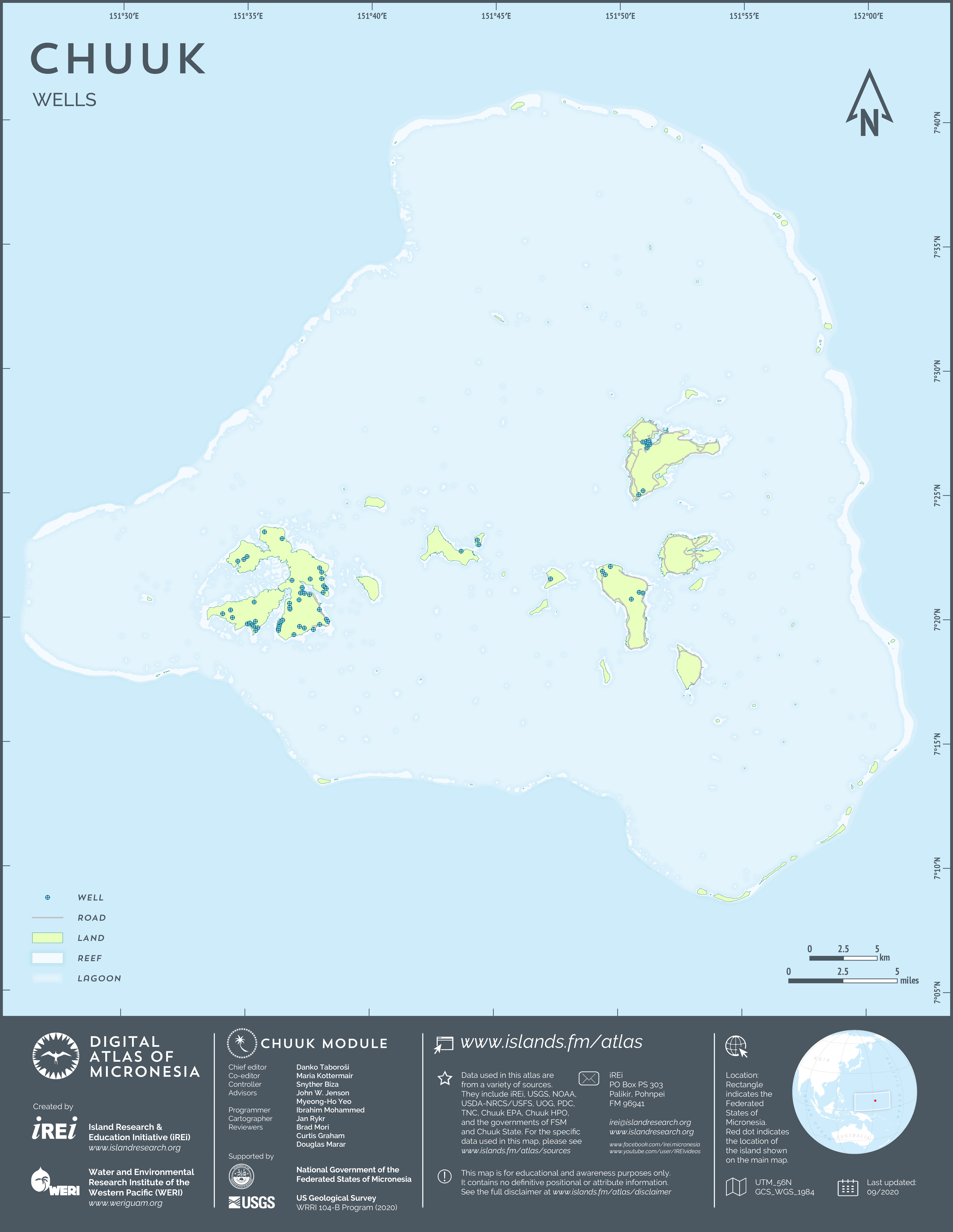
main logo

chuuk Maps: infrastructure

Transportation

Road network

Roads

This map shows the road network on the islands in Chuuk Lagoon. It only includes major roads. The dataset was created by Island Research & Education Initiative (iREi) (2020), by extracting data from the Open Street Map (2020) and formatting it for use in this atlas.

Bridges and causeways

This map shows major bridges and causeways on the islands in Chuuk Lagoon. The dataset was created by Island Research & Education Initiative (iREi) (2020), based on 2016 WorldView-2 satellite imagery by DigitalGlobe provided by U.S. Department of Agriculture (USDA) – Natural Resources Conservation Service (NRCS).

Air and sea transport

Port and airport locations

This map shows the locations of the international port and airport in Chuuk Lagoon. The dataset was created by Island Research & Education Initiative (iREi) (2020), based on 2016 WorldView-2 satellite imagery by DigitalGlobe provided by U.S. Department of Agriculture (USDA) – Natural Resources Conservation Service (NRCS).

Port and airport zones

This map shows the international port and airport zones in Chuuk Lagoon. The dataset was created by Island Research & Education Initiative (iREi) (2020) by outlining polygons based on 2016 WorldView-2 satellite imagery by DigitalGlobe provided by U.S. Department of Agriculture (USDA) – Natural Resources Conservation Service (NRCS). The dataset also includes the outline of the runway. The boundaries are not authoritative.

Coastal infrastructure

This map shows the most significant docks, piers, marinas, and anchorages in Chuuk Lagoon. The dataset was created by Island Research & Education Initiative (iREi) (2020) by interpreting 2016 WorldView-2 satellite imagery by DigitalGlobe provided by U.S. Department of Agriculture (USDA) – Natural Resources Conservation Service (NRCS) and compiling locations from a variety of sources, notably Geoview.

Residential

Houses

Locations of houses and other buildings

This map shows the footprints of key government offices (state, national, foreign) and other major buildings on the islands in Chuuk Lagoon. The dataset was created by Island Research & Education Initiative (iREi) (2020) by manually digitizing all structures visible in 2014 WorldView-2 satellite imagery by DigitalGlobe provided by U.S. Department of Agriculture (USDA) – Natural Resources Conservation Service (NRCS) and then converting the polygons into central points.

Footprints of houses and other buildings

This map shows the footprints of key government offices (state, national, foreign) and other major buildings on the islands in Chuuk Lagoon. The dataset was created by Island Research & Education Initiative (iREi) (2020) by manually digitizing all structures visible in 2014 WorldView-2 satellite imagery by DigitalGlobe provided by U.S. Department of Agriculture (USDA) – Natural Resources Conservation Service (NRCS).

Commercial

Businesses

Major businesses

This map shows office locations of major business entities on the islands in Chuuk Lagoon. The dataset was created by Island Research & Education Initiative (iREi) (2020), based on various sources including Open Street Maps and Google Maps and limited field verification.

Government

Government and NGO offices

Public sector

This map shows the footprints of key government offices (state, national, foreign) and other major quasi-governmental and non-governmental entities on the islands of Chuuk Lagoon. The dataset was created by Island Research & Education Initiative (iREi) (2020), based on the listing in the FSM Telecom Phonebook 2020 and field verification of office locations.

Health and education

Health care sites

Hospitals and clinics

This map shows the locations of hospitals, clinics, and dispensaries on the islands in Chuuk Lagoon. The data layer was created by Island Research & Education Initiative (iREi) (2020), based on field verification. Attribute information for the hospital is from the Pacific Disaster Center (PDC) (2013).

Schools and colleges

Schools

This map shows the locations of schools and colleges on the islands in Chuuk Lagoon. The data were developed by Island Research & Education Initiative (iREi) (2020), based on the list of public schools provided by Chuuk State Department of Education, list of private schools, and field verification of their locations.

Religion

Churches

Places of worship

This map shows the locations of churches on the islands in Chuuk Lagoon. The dataset was created by Island Research & Education Initiative (iREi) (2020), based on various sources, notably Geoview.

Safety and emergency

Fire stations

Fire stations

This map shows the locations of fire stations on the islands in Chuuk Lagoon. The original data were developed by the Pacific Disaster Center (PDC) as part of the 'Geospatial Information Development and Application to Support Effective Decision Making in the Federated States of Micronesia' project conducted in partnership with Island Research & Education Initiative (iREi) and College of Micronesia (COM), with funding from NOAA – Coastal Storms Program. The data were incorporated into PDC's DisasterAWARE decision-support system (2014). Island Research & Education Initiative (iREi) (2019) extracted a subset from the original dataset and formatted it for use in this atlas. The features were reviewed for accuracy and currentness.

Police stations

Police stations

This map shows the locations of police stations on the islands in Chuuk Lagoon. The data layer was created by Island Research & Education Initiative (iREi) (2020), based on field verification.

Utilities

Power supply

Power plants

This map shows the locations of power plants on the islands in Chuuk Lagoon. The original data layer was created by Island Research & Education Initiative (iREi) (2020), using data obtained through field verification and an older layer by the Pacific Disaster Center (PDC), created as part of the 'Geospatial Information Development and Application to Support Effective Decision Making in the Federated States of Micronesia' project conducted in partnership with Island Research & Education Initiative (iREi) and College of Micronesia (COM), with funding from NOAA – Coastal Storms Program, and incorporated into PDC's DisasterAWARE decision-support system (2014). Island Research & Education Initiative (iREi) (2019) extracted a subset from the original dataset and formatted it for use in this atlas. The features were reviewed for accuracy and currentness.

Fuel storage

This map shows the locations of fuel tanks on the islands in Chuuk Lagoon. The original data were developed by the Pacific Disaster Center (PDC) as part of the 'Geospatial Information Development and Application to Support Effective Decision Making in the Federated States of Micronesia' project conducted in partnership with Island Research & Education Initiative (iREi) and College of Micronesia (COM), with funding from NOAA – Coastal Storms Program. The data were incorporated into PDC's DisasterAWARE decision-support system (2014). Island Research & Education Initiative (iREi) (2019) extracted a subset from the original dataset and formatted it for use in this atlas. The features were reviewed for accuracy and currentness.

Water supply

Water reservoir

This map shows the location of one surface-water storage reservoir on Weno. The original data were developed by the Pacific Disaster Center (PDC) as part of the 'Geospatial Information Development and Application to Support Effective Decision Making in the Federated States of Micronesia' project conducted in partnership with Island Research & Education Initiative (iREi) and College of Micronesia (COM), with funding from NOAA – Coastal Storms Program. The data were incorporated into PDC's DisasterAWARE decision-support system (2014). Island Research & Education Initiative (iREi) (2019) extracted a subset from the original dataset and formatted it for use in this atlas. The features were reviewed for accuracy and currentness.

Water tanks

This map shows the locations of storage tanks for fresh water on the islands in Chuuk Lagoon. The original data were developed by the Pacific Disaster Center (PDC) as part of the 'Geospatial Information Development and Application to Support Effective Decision Making in the Federated States of Micronesia' project conducted in partnership with Island Research & Education Initiative (iREi) and College of Micronesia (COM), with funding from NOAA – Coastal Storms Program. The data were incorporated into PDC's DisasterAWARE decision-support system (2014). Island Research & Education Initiative (iREi) (2019) extracted a subset from the original dataset and formatted it for use in this atlas. The features were reviewed for accuracy and currentness.

Water treatment facilities

This map shows the locations of drinking water treatment facilities on the islands in Chuuk Lagoon. The original data were developed by the Pacific Disaster Center (PDC) as part of the 'Geospatial Information Development and Application to Support Effective Decision Making in the Federated States of Micronesia' project conducted in partnership with Island Research & Education Initiative (iREi) and College of Micronesia (COM), with funding from NOAA - Coastal Storms Program. The data were incorporated into PDC's DisasterAWARE decision-support system (2014). Island Research & Education Initiative (iREi) (2019) extracted a subset from the original dataset and formatted it for use in this atlas. The features were reviewed for accuracy and currentness.

Wells

This map shows the locations of wells recorded on the topographic map of Chuuk, 1:25,000 scale, published in 2001 by the U.S. Geological Survey (USGS). The wells are mostly shallow, dug wells, but may also include deeper, drilled wells on Weno and other islands. The data layer was created by Island Research & Education Initiative (iREi) (2020) by manually digitizing features from the U.S. Geological Survey (USGS) topographic map. The locations are approximate and may include features that no longer exist. It should be noted that Chuuk Lagoon has no karst terrain on high islands, so all groundwater there issues from volcanic aquifers.

Wastewater management

Wastewater

This map shows the location of wastewater treatment plant and related infrastructure on the islands in Chuuk Lagoon. The original data were developed by the Pacific Disaster Center (PDC) as part of the 'Geospatial Information Development and Application to Support Effective Decision Making in the Federated States of Micronesia' project conducted in partnership with Island Research & Education Initiative (iREi) and College of Micronesia (COM), with funding from NOAA – Coastal Storms Program. The data were incorporated into PDC's DisasterAWARE decision-support system (2014). Island Research & Education Initiative (iREi) (2019) extracted a subset from the original dataset and formatted it for use in this atlas. The features were reviewed for accuracy and currentness.

Communications

Communication infrastructure

This map shows the communication infrastructure on the islands in Chuuk Lagoon. The features shown include communication towers, Wi-Fi access points, and cell sites. The data layer was created by Island Research & Education Initiative (iREi) (2020), based on field verification and previously available data from the Pacific Disaster Center (PDC), created as part of the "Geospatial Information Development and Application to Support Effective Decision Making in the Federated States of Micronesia" project conducted in partnership with Island Research & Education Initiative (iREi) and College of Micronesia (COM), with funding from NOAA – Coastal Storms Program.

Cemeteries

Cemeteries

This map shows the locations of cemeteries on the islands in Chuuk Lagoon. The information was extracted by Island Research & Education Initiative (iREi) (2020) from Digital Line Graphs (DLGs) of U.S. Geological Survey (USGS) 1:25,000-scale topographic maps (1996-1997) and was not verified in the field.

Mining

Quarries

Quarries and dredge sites

This map shows the location of rock quarries and dredging basins on the islands in Chuuk Lagoon. The data layer was created by Island Research & Education Initiative (iREi) (2020), based on field verification and locations obtained from Geoview.